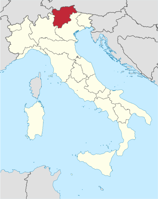
Fayl:Trentino-Alto Adige in Italy.svg

Size of this PNG preview of this SVG file: 477 × 599 pixels. Başqa çözüm: 191 × 240 pixels | 382 × 480 pixels | 611 × 768 pixels | 815 × 1.024 pixels | 1.630 × 2.048 pixels | 1.034 × 1.299 pixels.
Kerçek fayl (SVG faylı, nominal 1.034 × 1.299 piksel, fayl büyükligi: 1,67 MB)
Faylğa ait qısqa tarif
.svg)
.svg)
.svg)
.svg)
.svg)
.svg)
.svg)

-en.svg)

.svg)
.svg)
.svg)

_(US48).svg)
_(small_islands_magnified)_(-mini_map_-rivers).svg)
.svg)
_(extra_close)_(US48).svg)
.svg)
_(zoom).svg)

.svg)


_(UNMIK).svg)
.svg)
_(disputed_hatched).svg)
_(claimed_and_disputed_hatched).svg)
.svg)
.svg)
_(%2Ball_claims_hatched).svg)

.svg)
_(shade).svg)
_(shade)_(special_marker).svg)
_(-mini_map).svg)
_(-mini_map).svg)
_(-mini_map).svg)


.svg)

.svg)

Litsenziyalama
I, the copyright holder of this work, hereby publish it under the following licenses:

|
Permission is granted to copy, distribute and/or modify this document under the terms of the GNU Free Documentation License, Version 1.2 or any later version published by the Free Software Foundation; with no Invariant Sections, no Front-Cover Texts, and no Back-Cover Texts. A copy of the license is included in the section entitled GNU Free Documentation License. |
This file is licensed under the Creative Commons Attribution-Share Alike 3.0 Unported license.
- Azatsıñız:
- paylaşuv – qopyaluv, dağıtuv ve iletüv
- remiks etüv – uyğunlaştıruv
- Bu şartlar astında:
- attribution – You must give appropriate credit, provide a link to the license, and indicate if changes were made. You may do so in any reasonable manner, but not in any way that suggests the licensor endorses you or your use.
- aynı şekilde paylaşuv – If you remix, transform, or build upon the material, you must distribute your contributions under the same or compatible license as the original.
İstedigiñiz lisansnı seçebilirsiñiz.

|
I'd greatly appreciate, that you attribute this media file to Wikimedia Commons, if used outside Wikipedia or Commons. For use in publications such as books, newspapers, blogs, websites, please insert here the following line:
|
Faylnıñ keçmişi
Faylnıñ kerekli anki alını körmek içün tarihqa/saatqa basıñız.
| Tarih ve saat | Kiçik resim | En × boy | Qullanıcı | İzaat | |
|---|---|---|---|---|---|
| şimdiki | 18:07, 2011 s. iyünniñ 17 | | 1.034 × 1.299 (1,67 MB) | Foroa | Reverted to version as of 13:40, 17 June 2011 |
| 17:49, 2011 s. iyünniñ 17 |  | 1.034 × 1.299 (1,68 MB) | Gryffindor | Reverted to version as of 12:50, 17 June 2011 | |
| 13:40, 2011 s. iyünniñ 17 |  | 1.034 × 1.299 (1,67 MB) | TUBS | rv: [http://commons.wikimedia.org/wiki/User_talk:Gryffindor#File:Trentino-Alto_Adige_in_Italy.svg] | |
| 12:50, 2011 s. iyünniñ 17 |  | 1.034 × 1.299 (1,68 MB) | Gryffindor | Reverted to version as of 23:28, 15 June 2011 the depiction of the provinces is in order as they are de-facto regions | |
| 06:21, 2011 s. iyünniñ 16 |  | 1.034 × 1.299 (1,67 MB) | TUBS | Reverted to version as of 06:49, 14 June 2011. Please save as a new file. Borders shouldn't differ in that map series | |
| 23:28, 2011 s. iyünniñ 15 |  | 1.034 × 1.299 (1,68 MB) | Gryffindor | Reverted to version as of 20:15, 13 June 2011 both are autonomous provinces in an autonomous region, others do not have that | |
| 06:49, 2011 s. iyünniñ 14 |  | 1.034 × 1.299 (1,67 MB) | TUBS | Reverted to version as of 12:27, 7 March 2011: please give new filename and move to new category. doesn't make sense: other province borders aren' shown either | |
| 20:15, 2011 s. iyünniñ 13 |  | 1.034 × 1.299 (1,68 MB) | Kmusser | add province boundary | |
| 12:27, 2011 s. martnıñ 7 |  | 1.034 × 1.299 (1,67 MB) | TUBS |
Fayl qullanıluvı
Bu saife qullana bu fayldı:
Umumiy fayl qullanıluvı
Bu vikilerde bu fayldı qullana:
- als.wikipedia.org qullanım
- ar.wikipedia.org qullanım
- ast.wikipedia.org qullanım
- az.wikipedia.org qullanım
- bcl.wikipedia.org qullanım
- bg.wikipedia.org qullanım
- ca.wikipedia.org qullanım
- ceb.wikipedia.org qullanım
- co.wikipedia.org qullanım
- cs.wikipedia.org qullanım
- cy.wikipedia.org qullanım
- de.wikipedia.org qullanım
- de.wikivoyage.org qullanım
- diq.wikipedia.org qullanım
- el.wikipedia.org qullanım
- en.wikipedia.org qullanım
- eo.wikivoyage.org qullanım
- fi.wikipedia.org qullanım
- frr.wikipedia.org qullanım
- fr.wikipedia.org qullanım
- fr.wiktionary.org qullanım
- ga.wikipedia.org qullanım
- gd.wikipedia.org qullanım
- gl.wikipedia.org qullanım
- ia.wikipedia.org qullanım
- id.wikipedia.org qullanım
- incubator.wikimedia.org qullanım
- it.wikipedia.org qullanım
- it.wikivoyage.org qullanım
- jam.wikipedia.org qullanım
- kab.wikipedia.org qullanım
- ko.wikipedia.org qullanım
- la.wikipedia.org qullanım
- lb.wikipedia.org qullanım
- lij.wikipedia.org qullanım
- lld.wikipedia.org qullanım
- lmo.wikipedia.org qullanım
- lv.wikipedia.org qullanım
View more global usage of this file.