Fayl:Skjálfandafljót at Route 1.jpg

Kerçek fayl (5.760 × 3.840 piksel, fayl büyükligi: 14,08 MB, MIME çeşiti: image/jpeg)
Faylğa ait qısqa tarif
| Tasvir |
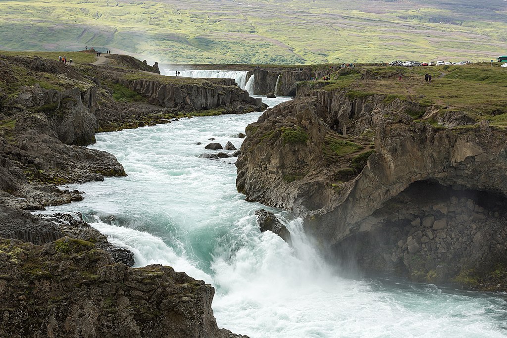
Dansk: Skjálfandafljót ved Hringvegur
Español: Río Skjálfandafljót visto desde la carretera nacional IS-1. En el fondo la Catarata de los Dioses, Región nororiental, Islandia.
Русский: Река Скьяульвандафльоут возле моста на дороге IS-1 в северном регионе Исландии Нордюрланд-Эйстра, сисла Нордюр-Тингейяр. На заднем плане водопад Годафосс.
Polski: Rzeka Skjálfandafljót w pobliżu mostu na drodze krajowej nr 1 w północnej Islandii. W tle widoczny jest spektakularny wodospad Goðafoss.
Português: Rio Skjálfandafljót visto da rodovia nacional IS-1. Ao fundo a Catarata dos Deuses, região Nordeste, Islândia.
Čeština: Peřeje na řece Skjálfandafljót, pohled z hlavní islandské silnice Hringvegur. V pozadí je vidět část impozantního vodopádu Goðafoss.
Deutsch: Der Skjálfandafljót-Fluss an der Ringstraße in Nordisland. Im Hintergrund der Goðafoss-Wasserfall.
Italiano: Il fiume Skjálfandafljót nei pressi della Hringvegur ("strada anello"), la principale strada islandese. Sullo sfondo è visibile la cascata Goðafoss.
Македонски: Реката Скјаулвандафљоут во северен Исланд. Во позадина се гледа величествениот водопад Годафос.
|
||||
| Tarih | |||||
| Menba | Öz işi | ||||
| Yaratıcı | Villy Fink Isaksen | ||||
| İzin (Faylnı yañıdan qullanuv) |
I, the copyright holder of this work, hereby publish it under the following license: This file is licensed under the Creative Commons Attribution-Share Alike 4.0 International license.
|
||||
| Camera location | | View this and other nearby images on: OpenStreetMap |
|---|
Assessment
|
This image was selected as picture of the day on Wikimedia Commons for 15 August 2016. It was captioned as follows: English: River Skjálfandafljót at Route 1 in northern Iceland. In the background is the spectacular waterfall Goðafoss. Other languages:
Čeština: Peřeje na řece Skjálfandafljót, pohled z hlavní islandské silnice Hringvegur. V pozadí je vidět část impozantního vodopádu Goðafoss. Dansk: Skjálfandafljót ved Hringvegur i baggrunden Goðafoss. Deutsch: Der Skjálfandafljót-Fluss an der Ringstraße in Nordisland. Im Hintergrund der Goðafoss-Wasserfall. English: River Skjálfandafljót at Route 1 in northern Iceland. In the background is the spectacular waterfall Goðafoss. Español: Río Skjálfandafljót visto desde la carretera nacional IS-1. En el fondo la Catarata de los Dioses, Región nororiental, Islandia. Italiano: Il fiume Skjálfandafljót nei pressi della Hringvegur ("strada anello"), la principale strada islandese. Sullo sfondo è visibile la cascata Goðafoss. Polski: Rzeka Skjálfandafljót w pobliżu mostu na drodze krajowej nr 1 w północnej Islandii. W tle widoczny jest spektakularny wodospad Goðafoss. Português: Rio Skjálfandafljót visto da rodovia nacional IS-1. Ao fundo a Catarata dos Deuses, região Nordeste, Islândia. Македонски: Реката Скјаулвандафљоут во северен Исланд. Во позадина се гледа величествениот водопад Годафос. |
This image has been assessed using the Quality image guidelines and is considered a Quality image.
|
Faylnıñ keçmişi
Faylnıñ kerekli anki alını körmek içün tarihqa/saatqa basıñız.
| Tarih ve saat | Kiçik resim | En × boy | Qullanıcı | İzaat | |
|---|---|---|---|---|---|
| şimdiki | 12:58, 2015 s. avgustnıñ 25 | | 5.760 × 3.840 (14,08 MB) | Villy Fink Isaksen | User created page with UploadWizard |
Fayl qullanıluvı
Bu saife qullana bu fayldı:
Umumiy fayl qullanıluvı
Bu vikilerde bu fayldı qullana:
- be-tarask.wikipedia.org qullanım
- cv.wikipedia.org qullanım
- en.wikipedia.org qullanım
- he.wikipedia.org qullanım
- hu.wikipedia.org qullanım
- ka.wikipedia.org qullanım
- ko.wikipedia.org qullanım
- lbe.wikipedia.org qullanım
- mg.wikipedia.org qullanım
- mk.wikipedia.org qullanım
- nn.wikipedia.org qullanım
- os.wikipedia.org qullanım
- pl.wikipedia.org qullanım
- pt.wikipedia.org qullanım
- ru.wikipedia.org qullanım
- ru.wikinews.org qullanım
- sah.wikipedia.org qullanım
- su.wikipedia.org qullanım
- tt.wikipedia.org qullanım
- uk.wikipedia.org qullanım
- vi.wikipedia.org qullanım
- zh.wikipedia.org qullanım