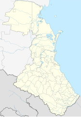
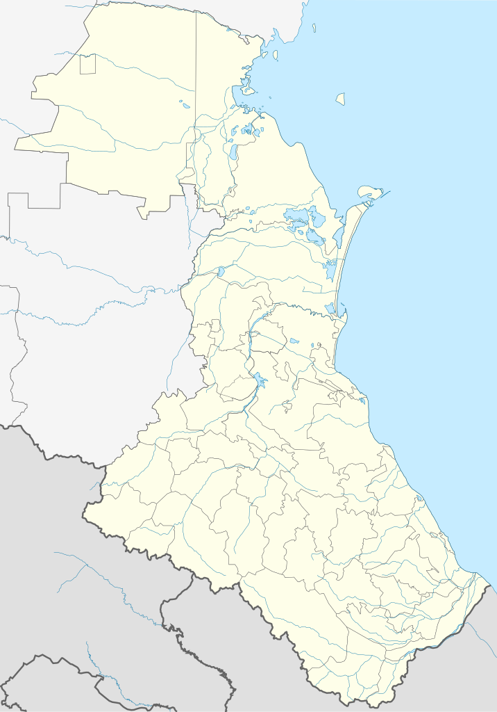
Fayl:Russia Dagestan location map.svg

Size of this PNG preview of this SVG file: 419 × 599 pixels. Başqa çözüm: 168 × 240 pixels | 335 × 480 pixels | 537 × 768 pixels | 716 × 1.024 pixels | 1.432 × 2.048 pixels | 744 × 1.064 pixels.
Kerçek fayl (SVG faylı, nominal 744 × 1.064 piksel, fayl büyükligi: 471 KB)
Faylğa ait qısqa tarif
| Tasvir |
English: Dagestan location map
Equirectangular projection, N/S stretching 136.7 %. True scale parallel: 43°00' N. Geographic limits of the map:
|
| Tarih | |
| Menba | Öz işi |
| Yaratıcı | Das steinerne Herz |
| Other versions | Derivative works of this file: Russia Dagestan relief location map.png |
Litsenziyalama
I, the copyright holder of this work, hereby publish it under the following licenses:
This file is licensed under the Creative Commons Attribution-Share Alike 3.0 Unported license.
- Azatsıñız:
- paylaşuv – qopyaluv, dağıtuv ve iletüv
- remiks etüv – uyğunlaştıruv
- Bu şartlar astında:
- attribution – You must give appropriate credit, provide a link to the license, and indicate if changes were made. You may do so in any reasonable manner, but not in any way that suggests the licensor endorses you or your use.
- aynı şekilde paylaşuv – If you remix, transform, or build upon the material, you must distribute your contributions under the same or compatible license as the original.

|
Permission is granted to copy, distribute and/or modify this document under the terms of the GNU Free Documentation License, Version 1.2 or any later version published by the Free Software Foundation; with no Invariant Sections, no Front-Cover Texts, and no Back-Cover Texts. A copy of the license is included in the section entitled GNU Free Documentation License. |
İstedigiñiz lisansnı seçebilirsiñiz.
Faylnıñ keçmişi
Faylnıñ kerekli anki alını körmek içün tarihqa/saatqa basıñız.
| Tarih ve saat | Kiçik resim | En × boy | Qullanıcı | İzaat | |
|---|---|---|---|---|---|
| şimdiki | 10:04, 2023 s. noyabrniñ 5 | | 744 × 1.064 (471 KB) | Takhirgeran Umar | Hid the contour of the border of Chechnya and Georgia, which spoiled the view |
| 22:22, 2022 s. iyülniñ 13 |  | 744 × 1.064 (480 KB) | Takhirgeran Umar | уточнение | |
| 08:00, 2020 s. fevralniñ 7 |  | 744 × 1.064 (479 KB) | Takhirgeran Umar | исп. | |
| 17:56, 2017 s. avgustnıñ 13 |  | 744 × 1.064 (321 KB) | Gajmar | Makhachkala border | |
| 14:00, 2017 s. iyülniñ 30 |  | 744 × 1.064 (245 KB) | Gajmar | background | |
| 13:14, 2016 s. noyabrniñ 14 |  | 744 × 1.064 (244 KB) | Stasyan117 | граница | |
| 10:36, 2015 s. noyabrniñ 30 |  | 744 × 1.064 (236 KB) | Takhirgeran Umar | округа | |
| 14:57, 2012 s. iyülniñ 21 |  | 744 × 1.064 (2,11 MB) | Takhirgeran Umar | Граница | |
| 19:02, 2011 s. sentâbrniñ 18 |  | 744 × 1.064 (2,1 MB) | Das steinerne Herz | изменение границы Казбековского района | |
| 14:32, 2011 s. sentâbrniñ 18 |  | 744 × 1.064 (2,1 MB) | Takhirgeran Umar | Reverted to version as of 12:45, 27 February 2011 |
Fayl qullanıluvı
Bu 65 saifeler qullana bu fayldı:
- Agvali
- Ahtı
- Akuşa
- Alburikent
- Açi-Su
- Babayurt
- Bavtugay
- Bejta
- Belici (şeer şeklinde qasaba)
- Botlih
- Buynaksk
- Dagestanskiye Ogni
- Derbent
- Dubki (Dağıstan)
- Dılım
- Gergebil
- Gunib
- Hasavyurt
- Hebda
- Hiv
- Hunzah
- Huçni
- Karabudahkent
- Karata
- Kaspiysk
- Kasumkent
- Komsomolskiy (Dağıstan)
- Korkmaskala
- Kumuh
- Kurah
- Kâhulay
- Leninkent (şeer şeklinde qasaba)
- Levaşi (Dağıstan)
- Macalis
- Magaramkent
- Mahaçqala
- Mamedkala
- Manas (Dağıstan)
- Mehelta
- Novokayakent
- Novolakskoye
- Novıy Kâhulay
- Novıy Sulak
- Qızlar
- Qızılyurt
- Rutul
- Semender (şeer şeklinde qasaba)
- Sergokala
- Sulak (Dağıstan)
- Tarki
- Tarumovka (Dağıstan)
- Terekli-Mekteb
- Tlârata (Tlârata rayonı)
- Tpig
- Tsunta
- Tsurib
- Tübe
- Urkarah
- Usuhçay
- Vaçi
- Yizbirbaş
- Yujno-Suhokumsk
- Şamhal (şeer şeklinde qasaba)
- Şamilkala
- Şablon:Location map Rusiye Dağıstan
Umumiy fayl qullanıluvı
Bu vikilerde bu fayldı qullana:
- af.wikipedia.org qullanım
- ar.wikipedia.org qullanım
- av.wikipedia.org qullanım
- Дагъистан
- МахӀачхъала
- ЦӀобокь
- Сулахъ
- Шура
- Хубар
- Хунзахъ мухъ
- МелъелтӀа
- СугъралӀ
- ЧӀарада мухъ
- Халип:БакӀКарта
- Халип:БакӀКарта Россия Дагъистан
- Халип:Бак1Карта/doc
- Дербендалъул ЖумгӀа мажгит
- ЖумгӀа мажгит (МахӀачхъала)
- МахӀачхъала (аэропорт)
- Гъебгъуда
- Къеди
- Хунзахъ
- ГӀаймаки
- ГӀахьалчӀи
- КӀудияб ГьоцӀалӀ
- Хьонохъ (ЦӀумада мухъ)
- ГӀириб
- Халип:БакӀКарта/doc
- Хьинуб
- Нукъуш
- Рулдаб
- ЦӀуриб
- Магъар
- ЦӀулда
- Цемер
- Доронуб
- ХӀурухъ
- Гьилиб
- Гьочоб
- Мугурухъ
- Рисиб
- ЛъаратӀа мухъ
- ГӀурада
- КӀкӀаратӀа
- Хьиндахъ (Хунзахъ мухъ)
- Коло
- ГӀарани
- МочӀохъ
View more global usage of this file.