Fayl:Pont sur l'Orb, Roquebrun 02.jpg
Size of this preview: 800 × 534 pixels. Başqa çözüm: 320 × 214 pixels | 640 × 427 pixels | 1.024 × 683 pixels | 1.280 × 854 pixels | 2.560 × 1.708 pixels | 7.244 × 4.834 pixels.
Kerçek fayl (7.244 × 4.834 piksel, fayl büyükligi: 24,2 MB, MIME çeşiti: image/jpeg)
Faylğa ait qısqa tarif
| Tasvir |
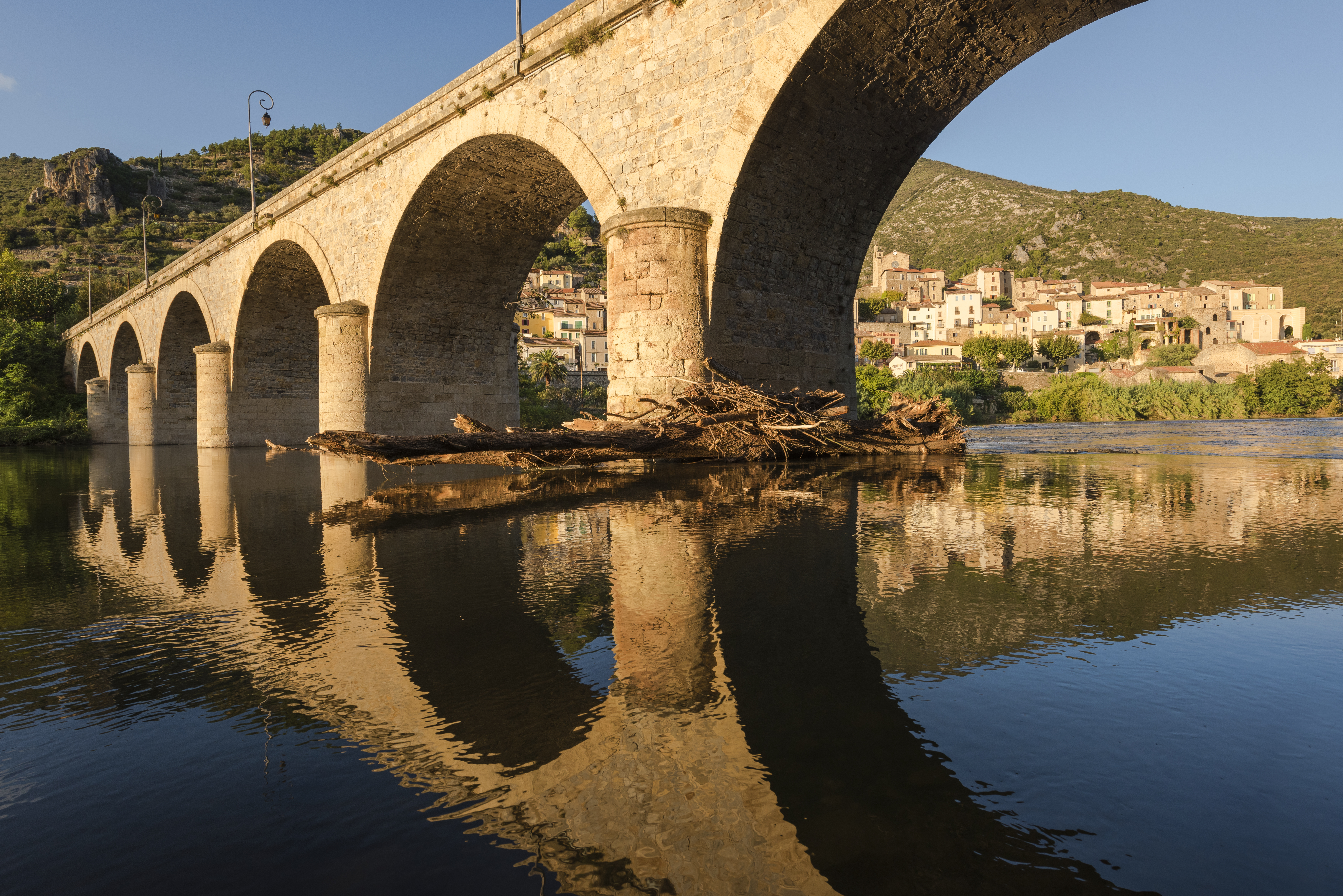
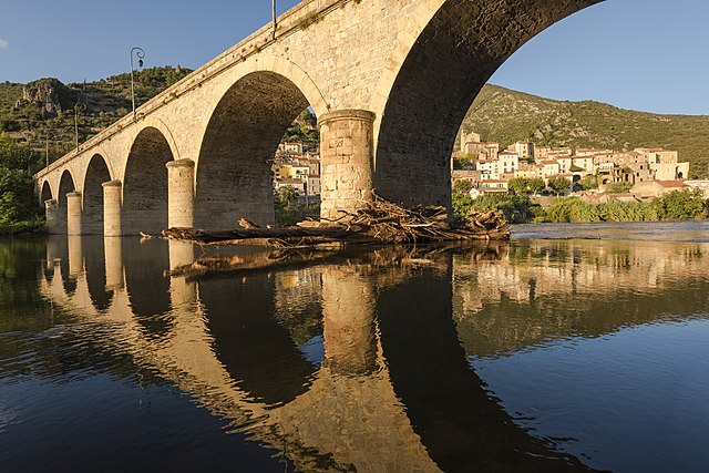
Français : Le pont sur l'Orb, pont en arc à 7 arches datant de 1870. Et dans le fond une partie du village de Roquebrun, Hérault, France. Parc naturel régional du Haut-Languedoc. English: The Bridge above the Orb River, arch bridge of 7 archs dated from 1870. And in the background a part of the village of Roquebrun, Hérault, France. Haut-Languedoc Regional Natural Park.
Português: Ponte de sete arcos sobre o rio Orb datada de 1870. Ao fundo vê-se parte da comuna francesa de Roquebrun, em Hérault.
Bosanski: Most iznad rijeke Orb i selo Roquebrun, Hérault, Francuska, regionalni prirodni park Haut-Languedoc.
Čeština: Most přes řeku Orb a vesnice Roquebrun, departement Hérault, Francie. Přírodní park Haut-Languedoc Regional Natural Park.
Español: El puente sobre el río Orb y el pueblo de Roquebrun, Hérault, Francia. Parque Natural Regional del Alto Languedoc.
Magyar: Híd az Orb folyó felett, Roquebrun településnél (Haut-Languedoc Regionális Természetvédelmi Park, Hérault, Franciaország)
|
| Tarih | Taken on 2 oktâbr 2014, 18:41:32 |
| Menba | Öz işi |
| Yaratıcı | Christian Ferrer |
| İzin (Faylnı yañıdan qullanuv) |
I, the copyright holder of this work, hereby publish it under the following license: This file is licensed under the Creative Commons Attribution 4.0 International license.
|
| Camera location | | View this and other nearby images on: OpenStreetMap |
|---|
|
This image was selected as picture of the day on Wikimedia Commons for 2 June 2015. It was captioned as follows: English: The Bridge above the Orb River and the village of Roquebrun, Hérault, France. Haut-Languedoc Regional Natural Park. Other languages:
Bosanski: Most iznad rijeke Orb i selo Roquebrun, Hérault, Francuska, regionalni prirodni park Haut-Languedoc. Čeština: Most přes řeku Orb a vesnice Roquebrun, departement Hérault, Francie. Přírodní park Haut-Languedoc Regional Natural Park. English: The Bridge above the Orb River and the village of Roquebrun, Hérault, France. Haut-Languedoc Regional Natural Park. Español: El puente sobre el río Orb y el pueblo de Roquebrun, Hérault, Francia. Parque Natural Regional del Alto Languedoc. Français : Le pont sur l’Orb et le village de Roquebrun, Hérault, France. Parc naturel régional du Haut-Languedoc. Magyar: Híd az Orb folyó felett, Roquebrun településnél (Haut-Languedoc Regionális Természetvédelmi Park, Hérault, Franciaország) Português: Ponte de sete arcos sobre o rio Orb datada de 1870. Ao fundo vê-se parte da comuna francesa de Roquebrun, em Hérault. |
Faylnıñ keçmişi
Faylnıñ kerekli anki alını körmek içün tarihqa/saatqa basıñız.
| Tarih ve saat | Kiçik resim | En × boy | Qullanıcı | İzaat | |
|---|---|---|---|---|---|
| şimdiki | 17:15, 2014 s. noyabrniñ 7 | | 7.244 × 4.834 (24,2 MB) | Christian Ferrer | color |
| 16:59, 2014 s. noyabrniñ 7 |  | 7.244 × 4.834 (23,04 MB) | Christian Ferrer | User created page with UploadWizard |
Fayl qullanıluvı
Bu saife qullana bu fayldı:
Umumiy fayl qullanıluvı
Bu vikilerde bu fayldı qullana:
- be-tarask.wikipedia.org qullanım
- bn.wikipedia.org qullanım
- cv.wikipedia.org qullanım
- de.wikivoyage.org qullanım
- de.wiktionary.org qullanım
- en.wikipedia.org qullanım
- hu.wikipedia.org qullanım
- it.wikipedia.org qullanım
- it.wiktionary.org qullanım
- ka.wikipedia.org qullanım
- ko.wikipedia.org qullanım
- krc.wikipedia.org qullanım
- lbe.wikipedia.org qullanım
- ms.wikipedia.org qullanım
- os.wikipedia.org qullanım
- pt.wikipedia.org qullanım
- ru.wikipedia.org qullanım
- ru.wikinews.org qullanım
- sah.wikipedia.org qullanım
- tt.wikipedia.org qullanım
- uk.wikipedia.org qullanım
- xal.wikipedia.org qullanım
- zh.wikipedia.org qullanım