Fayl:Political map of the World (November 2011).png
Size of this preview: 800 × 437 pixels. Başqa çözüm: 320 × 175 pixels | 640 × 350 pixels | 1.024 × 560 pixels | 1.280 × 700 pixels | 2.560 × 1.400 pixels | 4.572 × 2.500 pixels.
Kerçek fayl (4.572 × 2.500 piksel, fayl büyükligi: 3,46 MB, MIME çeşiti: image/png)
Faylğa ait qısqa tarif

|
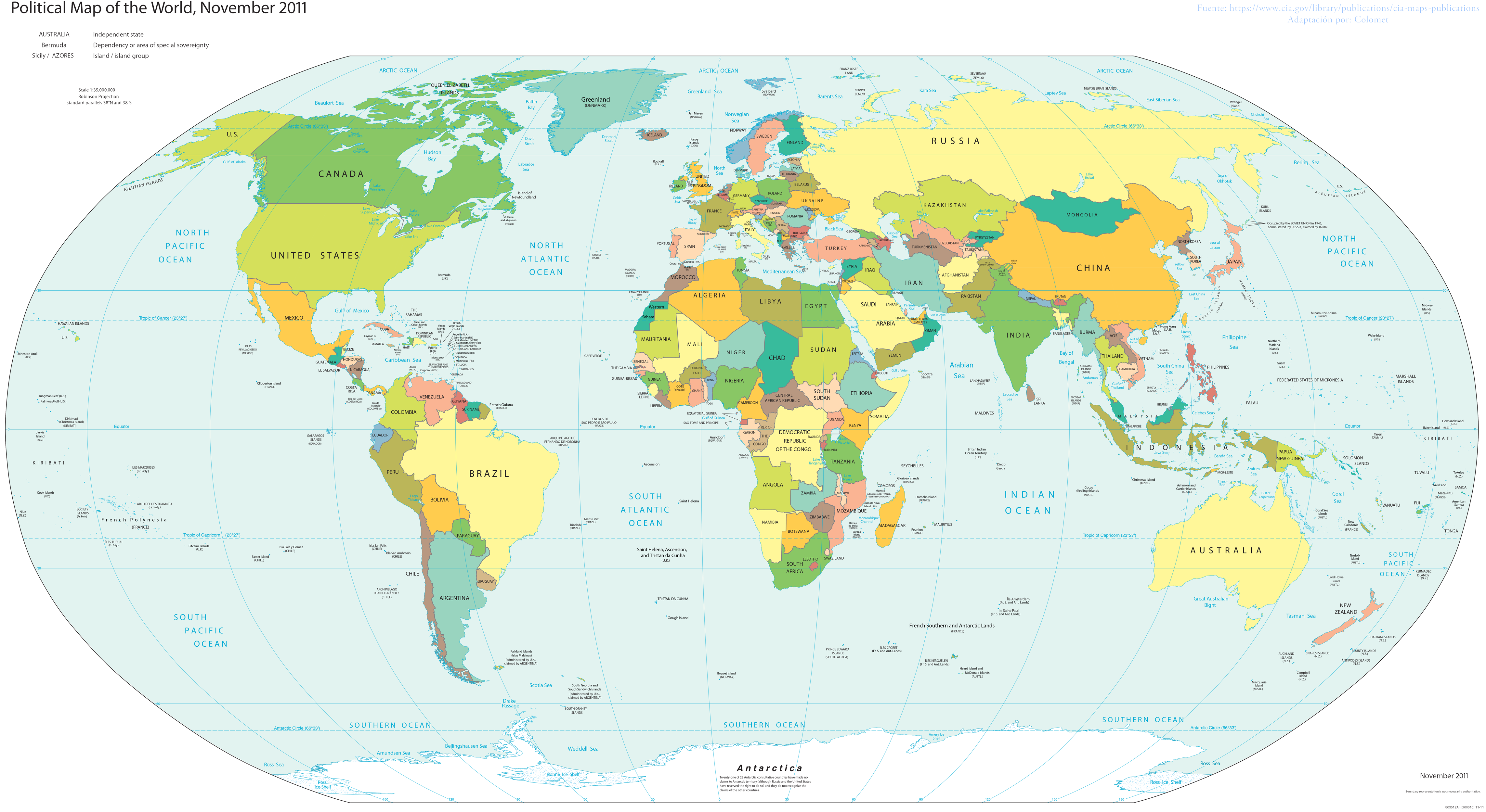
This file requires updating because: s/CZECH REP./CZECHIA; s/SWAZILAND/eSWATINI; label TAIWAN separately from CHINA In doing so, you could add a timestamp to the file.
|
| Tasvir |
English: World map; partially inaccurate, as Taiwan is shown as part of China. POV-pushing users have reverted attempts to update this map to include other partially-unrecognized countries, due to the 2011 date on the map; however, South Sudan did not exist in 2011, and it's still on the map. |
| Tarih | |
| Menba | Basado en el Mapa politico de la CIA |
| Yaratıcı | Colomet |
| Other versions |
 |


.png)
Litsenziyalama
I, the copyright holder of this work, hereby publish it under the following license:
This file is licensed under the Creative Commons Attribution-Share Alike 3.0 Unported license.
- Azatsıñız:
- paylaşuv – qopyaluv, dağıtuv ve iletüv
- remiks etüv – uyğunlaştıruv
- Bu şartlar astında:
- attribution – You must give appropriate credit, provide a link to the license, and indicate if changes were made. You may do so in any reasonable manner, but not in any way that suggests the licensor endorses you or your use.
- aynı şekilde paylaşuv – If you remix, transform, or build upon the material, you must distribute your contributions under the same or compatible license as the original.
This image is in the public domain because it contains materials that originally came from the United States Central Intelligence Agency's World Factbook.
|
 |
Faylnıñ keçmişi
Faylnıñ kerekli anki alını körmek içün tarihqa/saatqa basıñız.
.png&dir=prev)
.png&offset=20170108210230)
.png&offset=&limit=20)
.png&offset=&limit=50)
.png&offset=&limit=100)
.png&offset=&limit=250)
.png&offset=&limit=500)
| Tarih ve saat | Kiçik resim | En × boy | Qullanıcı | İzaat | |
|---|---|---|---|---|---|
| şimdiki | 18:00, 2017 s. noyabrniñ 24 | | 4.572 × 2.500 (3,46 MB) | Rob984 | Reverted to version as of 23:35, 16 November 2017 (UTC) Crimea wasn't controlled by Russia in November 2011. Please fix the date. Also dont add Turkish occupation zones as Turkey, they are not. |
| 19:17, 2017 s. noyabrniñ 23 |  | 4.572 × 2.500 (3,43 MB) | Koxem918 | Slight coloring fix in Russian area around Abkhazia. | |
| 19:13, 2017 s. noyabrniñ 23 |  | 4.572 × 2.500 (3,43 MB) | Koxem918 | Added back in Russian control over Ukraine as well as Turkish control of northern Syria, neither of which had been established when the map was created. Also added back in Abkhazia. | |
| 23:35, 2017 s. noyabrniñ 16 |  | 4.572 × 2.500 (3,46 MB) | Mitolith | Reverted to version as of 23:13, 31 January 2012 (UTC) | |
| 02:37, 2017 s. iyülniñ 30 |  | 4.572 × 2.500 (2,79 MB) | Salem.leo.1 | Added in Donetsk's People's Republic, South Ossetia, Abkhazia | |
| 21:03, 2017 s. martnıñ 26 |  | 4.572 × 2.500 (3,43 MB) | Salem Leo | Added in Kosovo. | |
| 19:58, 2017 s. martnıñ 26 |  | 4.572 × 2.500 (3,43 MB) | Salem Leo | Added in area controlled by Turkey in Northern Syria due to Operation Euphrates Shield. | |
| 18:45, 2017 s. martnıñ 26 |  | 4.572 × 2.500 (3,41 MB) | Salem Leo | Colouring fix. | |
| 21:04, 2017 s. yanvarniñ 8 |  | 4.572 × 2.500 (3,43 MB) | Rob984 | Reverted to version as of 03:16, 30 November 2016 (UTC) ISIS is not a recognised country.... | |
| 21:02, 2017 s. yanvarniñ 8 |  | 4.572 × 2.500 (3,43 MB) | Rob984 | Reverted to version as of 04:11, 30 November 2016 (UTC) |
Fayl qullanıluvı
Bu saife qullana bu fayldı:
Umumiy fayl qullanıluvı
Bu vikilerde bu fayldı qullana:
- ar.wikipedia.org qullanım
- awa.wikipedia.org qullanım
- cv.wikipedia.org qullanım
- en.wikipedia.org qullanım
- eo.wikipedia.org qullanım
- es.wikipedia.org qullanım
- fa.wikiquote.org qullanım
- fi.wikipedia.org qullanım
- gl.wikipedia.org qullanım
- ha.wikipedia.org qullanım
- he.wikipedia.org qullanım
- ht.wikipedia.org qullanım
- incubator.wikimedia.org qullanım
- ka.wikipedia.org qullanım
- lo.wikipedia.org qullanım
- nl.wikipedia.org qullanım
- pt.wikipedia.org qullanım
- ru.wikipedia.org qullanım
- sco.wikipedia.org qullanım
- si.wikipedia.org qullanım
- sv.wikipedia.org qullanım
- th.wikipedia.org qullanım
- tly.wikipedia.org qullanım
- uk.wikipedia.org qullanım
- za.wikipedia.org qullanım
.png)