Fayl:Indonesia provinces english.png

Size of this preview: 800 × 365 pixels. Başqa çözüm: 320 × 146 pixels | 640 × 292 pixels | 1.628 × 742 pixels.
Kerçek fayl (1.628 × 742 piksel, fayl büyükligi: 92 KB, MIME çeşiti: image/png)

|
File:Indonesia, administrative divisions - en - monochrome.svg is a vector version of this file. It should be used in place of this PNG file when not inferior.
File:Indonesia provinces english.png → File:Indonesia, administrative divisions - en - monochrome.svg
For more information, see Help:SVG. |
 |

|
This file requires updating because: In 2022, the Papua provinces changed from 2 provinces to 6 provinces. In doing so, you could add a timestamp to the file.
|
Faylğa ait qısqa tarif
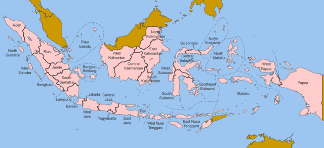
Map of the provinces of Indonesia in English.
Made by User:Golbez based on a PD CIA map, using other sources to guesstimate the extent of West Irian Jaya and West Sulawesi.
derivative works
Derivative works of this file: Indonesia, administrative divisions - en - monochrome.svg
Litsenziyalama
I, the copyright holder of this work, hereby publish it under the following licenses:

|
Permission is granted to copy, distribute and/or modify this document under the terms of the GNU Free Documentation License, Version 1.2 or any later version published by the Free Software Foundation; with no Invariant Sections, no Front-Cover Texts, and no Back-Cover Texts. A copy of the license is included in the section entitled GNU Free Documentation License. |
| This file is licensed under the Creative Commons Attribution-Share Alike 3.0 Unported license. | ||
| ||
| This licensing tag was added to this file as part of the GFDL licensing update. |
This file is licensed under the Creative Commons Attribution 2.5 Generic license.
- Azatsıñız:
- paylaşuv – qopyaluv, dağıtuv ve iletüv
- remiks etüv – uyğunlaştıruv
- Bu şartlar astında:
- attribution – You must give appropriate credit, provide a link to the license, and indicate if changes were made. You may do so in any reasonable manner, but not in any way that suggests the licensor endorses you or your use.
İstedigiñiz lisansnı seçebilirsiñiz.
Faylnıñ keçmişi
Faylnıñ kerekli anki alını körmek içün tarihqa/saatqa basıñız.
| Tarih ve saat | Kiçik resim | En × boy | Qullanıcı | İzaat | |
|---|---|---|---|---|---|
| şimdiki | 12:40, 2020 s. oktâbrniñ 25 | | 1.628 × 742 (92 KB) | Afrogindahood | Addition of North Kalimantan province |
| 07:54, 2006 s. yanvarniñ 8 | 1.500 × 590 (77 KB) | Golbez | Map of the provinces of Indonesian in English. Made by User:Golbez based on a PD CIA map, using other sources to guesstimate the extent of West Irian Jaya and West Sulawesi. Category:Maps of Indonesia |
Fayl qullanıluvı
Bu saife qullana bu fayldı:
Umumiy fayl qullanıluvı
Bu vikilerde bu fayldı qullana:
- arz.wikipedia.org qullanım
- ba.wikipedia.org qullanım
- be-tarask.wikipedia.org qullanım
- blk.wikipedia.org qullanım
- bxr.wikipedia.org qullanım
- ca.wikipedia.org qullanım
- ceb.wikipedia.org qullanım
- csb.wikipedia.org qullanım
- cs.wikipedia.org qullanım
- cy.wikipedia.org qullanım
- da.wikipedia.org qullanım
- diq.wikipedia.org qullanım
- dv.wikipedia.org qullanım
- en.wikipedia.org qullanım
- es.wikipedia.org qullanım
- fr.wikipedia.org qullanım
- gd.wikipedia.org qullanım
- gl.wikipedia.org qullanım
- ht.wikipedia.org qullanım
- hu.wikipedia.org qullanım
- incubator.wikimedia.org qullanım
- it.wikipedia.org qullanım
- ja.wikipedia.org qullanım
- kaa.wikipedia.org qullanım
- kk.wikipedia.org qullanım
- km.wikipedia.org qullanım
- kn.wikipedia.org qullanım
- kv.wikipedia.org qullanım
- kw.wikipedia.org qullanım
- lij.wikipedia.org qullanım
- lmo.wikipedia.org qullanım
- ln.wikipedia.org qullanım
- lt.wikipedia.org qullanım
- lv.wikipedia.org qullanım
- mg.wikipedia.org qullanım
- mhr.wikipedia.org qullanım
- ml.wikipedia.org qullanım
- mn.wikipedia.org qullanım
- my.wikipedia.org qullanım
- mzn.wikipedia.org qullanım
- new.wikipedia.org qullanım
- nl.wikipedia.org qullanım
- nn.wikipedia.org qullanım
- pag.wikipedia.org qullanım
- pam.wikipedia.org qullanım
- pap.wikipedia.org qullanım
- pms.wikipedia.org qullanım
- pnb.wikipedia.org qullanım
View more global usage of this file.