Fayl:Eesti põhjarannik.jpg

Size of this preview: 800 × 424 pixels. Başqa çözüm: 320 × 170 pixels | 640 × 340 pixels | 1.024 × 543 pixels | 1.280 × 679 pixels | 2.560 × 1.358 pixels | 12.875 × 6.831 pixels.
Kerçek fayl (12.875 × 6.831 piksel, fayl büyükligi: 48,22 MB, MIME çeşiti: image/jpeg)
Faylğa ait qısqa tarif
| Warning | The original file is very high-resolution. It might not load properly or could cause your browser to freeze when opened at full size. |
|---|
| Tasvir |
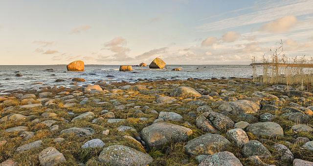
Eesti: Põhja-Eesti kivine rannajoon Pärispea poolsaarel Lahemaa rahvuspargis. English: Pärispea Peninsula, Lahemaa National Park. There are glacial boulders in the picture, that are typical to Estonian northern coast. |
| Tarih | |
| Menba | Öz işi |
| Yaratıcı | Abrget47j |
| Camera location | | View this and other nearby images on: OpenStreetMap |
|---|
|
This image was selected as picture of the day on Wikimedia Commons for 19 April 2014. It was captioned as follows: English: Pärispea peninsula, Lahemaa National Park, Estonia. Other languages:
Bosanski: Poluostrvo Pärispea, Nacionalni park Lahemaa. Eesti: Põhja-Eesti kivine rannajoon Pärispea poolsaarel Lahemaa rahvuspargis. English: Pärispea peninsula, Lahemaa National Park, Estonia. Nederlands: Het schiereiland Pärispea in het Nationaal Park Lahemaa in het noorden van Estland aan de Finse Golf. 中文: 爱沙尼亚拉赫马国家公园佩里斯佩半岛。 |
Litsenziyalama
I, the copyright holder of this work, hereby publish it under the following license:
This file is licensed under the Creative Commons Attribution-Share Alike 3.0 Unported license.
- Azatsıñız:
- paylaşuv – qopyaluv, dağıtuv ve iletüv
- remiks etüv – uyğunlaştıruv
- Bu şartlar astında:
- attribution – You must give appropriate credit, provide a link to the license, and indicate if changes were made. You may do so in any reasonable manner, but not in any way that suggests the licensor endorses you or your use.
- aynı şekilde paylaşuv – If you remix, transform, or build upon the material, you must distribute your contributions under the same or compatible license as the original.
| Annotations | This image is annotated: View the annotations at Commons |
This image was uploaded as part of Estonian nature photos competition 2013.
|
Faylnıñ keçmişi
Faylnıñ kerekli anki alını körmek içün tarihqa/saatqa basıñız.
| Tarih ve saat | Kiçik resim | En × boy | Qullanıcı | İzaat | |
|---|---|---|---|---|---|
| şimdiki | 18:53, 2013 s. dekabrniñ 9 | | 12.875 × 6.831 (48,22 MB) | Abrget47j | horizon straightened |
| 19:34, 2013 s. dekabrniñ 3 |  | 12.278 × 6.575 (46,86 MB) | (qullanıcı adı yoq etildi) | stitching errors removed | |
| 09:12, 2013 s. noyabrniñ 26 |  | 12.109 × 7.230 (49,25 MB) | (qullanıcı adı yoq etildi) | User created page with UploadWizard |
Fayl qullanıluvı
Bu saife qullana bu fayldı:
Umumiy fayl qullanıluvı
Bu vikilerde bu fayldı qullana:
- be-tarask.wikipedia.org qullanım
- bn.wikipedia.org qullanım
- cv.wikipedia.org qullanım
- de.wikipedia.org qullanım
- en.wikipedia.org qullanım
- et.wikipedia.org qullanım
- fiu-vro.wikipedia.org qullanım
- fr.wikipedia.org qullanım
- hu.wikipedia.org qullanım
- ig.wiktionary.org qullanım
- incubator.wikimedia.org qullanım
- ka.wikipedia.org qullanım
- kk.wikipedia.org qullanım
- ko.wikipedia.org qullanım
- krc.wikipedia.org qullanım
- lbe.wikipedia.org qullanım
- lv.wikipedia.org qullanım
- mg.wikipedia.org qullanım
- mk.wikipedia.org qullanım
- os.wikipedia.org qullanım
- pt.wikipedia.org qullanım
- ro.wikipedia.org qullanım
- ru.wikipedia.org qullanım
- ru.wikinews.org qullanım
- sah.wikipedia.org qullanım
- sv.wikipedia.org qullanım
- tr.wikipedia.org qullanım
- tt.wikipedia.org qullanım
- uk.wikipedia.org qullanım
- vi.wikipedia.org qullanım
- www.wikidata.org qullanım
- xal.wikipedia.org qullanım
- zh.wikipedia.org qullanım
View more global usage of this file.