Fayl:Eerste zonnestralen strijken over een winters landschap. Pad tussen Put van Nederhorst en Langweerderwielen. Locatie, Langweerderwielen (Langwarder Wielen) en omgeving 01.jpg

Size of this preview: 800 × 473 pixels. Başqa çözüm: 320 × 189 pixels | 640 × 378 pixels | 1.024 × 605 pixels | 1.280 × 756 pixels | 2.560 × 1.513 pixels | 5.183 × 3.063 pixels.
Kerçek fayl (5.183 × 3.063 piksel, fayl büyükligi: 12,69 MB, MIME çeşiti: image/jpeg)
_en_omgeving_01.jpg)
Faylğa ait qısqa tarif
| Tasvir |
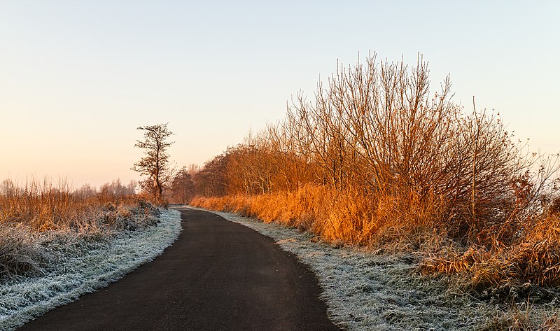
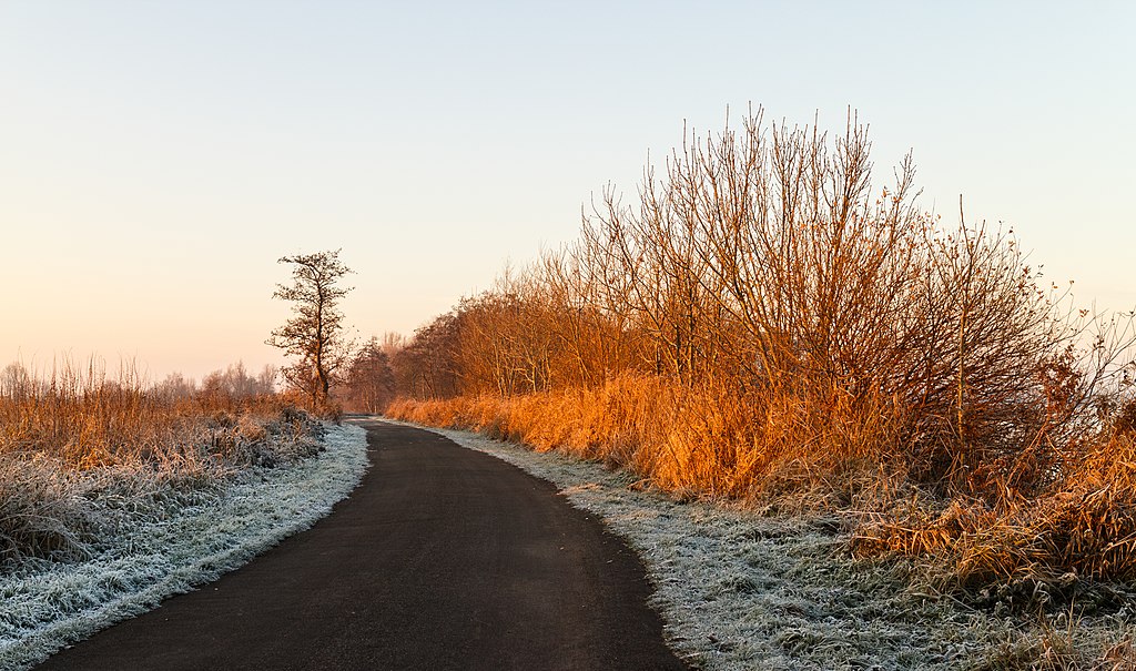
Nederlands: Eerste zonnestralen strijken over een winters landschap. Pad tussen Put van Nederhorst en Langweerderwielen. Locatie, Langweerderwielen (Langwarder Wielen) en omgeving, De Friese Meren, Friesland.
English: First sunbeams sweep over a winter landscape. Path between Put van Nederhorst and Langweerderwielen. Location, Langweerderwielen (Langwarder Wielen) and surroundings, De Friese Meren, Friesland, Netherlands.
Español: Paisaje invernal iluminado por los primeros rayos del sol. Camino entre Put van Nederhorst y Langweerderwielen en el municipio De Fryske Marren, Frisia, Países Bajos.
Polski: Pierwsze promienie słońca omiatające zimowy krajobraz. Droga pomiędzy jeziorami Put van Nederhorst i Langwarder Wielen w gminie De Fryske Marren, we Fryzji, w Holandii.
Українська: Перші сонячні промені освітлюють зимовий ландшафт на дорозі в муніципалітеті Де-Фрізке-Маррен, Фрисландія, Нідерланди.
Magyar: Az első napsugarak egy téli tájon Put van Nederhorst és Langweerderwielen között (De Friese Meren, Frízföld, Hollandia)
Македонски: Први сончеви зраци над патека во зимски предел. Фризија, Холандија.
Português: Paisagem de inverno no caminho entre Put van Nederhorst e Langweerderwielen no município De Friese Meren, Frísia, Países Baixos. |
| Tarih | |
| Menba | Öz işi |
| Yaratıcı | Dominicus Johannes Bergsma |
| Camera location | | View this and other nearby images on: OpenStreetMap |
|---|
_en_omgeving_01.jpg¶ms=052.965356_N_0005.747976_E_globe:Earth_type:camera__&language=crh)
Assessment
|
_en_omgeving_01.jpg)
This image was selected as picture of the day on Wikimedia Commons for 14 December 2017. It was captioned as follows: English: First sunbeams sweep over a winter landscape. Path between Put van Nederhorst and Langweerderwielen. Location, Langweerderwielen (Langwarder Wielen) and surroundings, De Fryske Marren, Friesland, Netherlands. Other languages:
English: First sunbeams sweep over a winter landscape. Path between Put van Nederhorst and Langweerderwielen. Location, Langweerderwielen (Langwarder Wielen) and surroundings, De Fryske Marren, Friesland, Netherlands. Español: Paisaje invernal iluminado por los primeros rayos del sol. Camino entre Put van Nederhorst y Langweerderwielen en el municipio De Fryske Marren, Frisia, Países Bajos. Magyar: Az első napsugarak egy téli tájon Put van Nederhorst és Langweerderwielen között (De Friese Meren, Frízföld, Hollandia) Nederlands: Wintertafereel op het pad tussen de Put van Nederhorst en de Langweerderwielen in de gemeente De Friese Meren Polski: Pierwsze promienie słońca omiatające zimowy krajobraz. Droga pomiędzy jeziorami Put van Nederhorst i Langwarder Wielen w gminie De Fryske Marren, we Fryzji, w Holandii. Português: Paisagem de inverno no caminho entre Put van Nederhorst e Langweerderwielen no município De Friese Meren, Frísia, Países Baixos. Македонски: Први сончеви зраци над патека во зимски предел. Фризија, Холандија. Українська: Перші сонячні промені освітлюють зимовий ландшафт на дорозі в муніципалітеті Де-Фрізке-Маррен, Фрисландія, Нідерланди. |
Litsenziyalama
I, the copyright holder of this work, hereby publish it under the following license:
This file is licensed under the Creative Commons Attribution-Share Alike 4.0 International license.
- Azatsıñız:
- paylaşuv – qopyaluv, dağıtuv ve iletüv
- remiks etüv – uyğunlaştıruv
- Bu şartlar astında:
- attribution – You must give appropriate credit, provide a link to the license, and indicate if changes were made. You may do so in any reasonable manner, but not in any way that suggests the licensor endorses you or your use.
- aynı şekilde paylaşuv – If you remix, transform, or build upon the material, you must distribute your contributions under the same or compatible license as the original.
Faylnıñ keçmişi
Faylnıñ kerekli anki alını körmek içün tarihqa/saatqa basıñız.
| Tarih ve saat | Kiçik resim | En × boy | Qullanıcı | İzaat | |
|---|---|---|---|---|---|
| şimdiki | 18:34, 2016 s. dekabrniñ 10 | | 5.183 × 3.063 (12,69 MB) | Famberhorst | User created page with UploadWizard |
Fayl qullanıluvı
Bu saife qullana bu fayldı:
Umumiy fayl qullanıluvı
Bu vikilerde bu fayldı qullana:
- av.wikipedia.org qullanım
- be-tarask.wikipedia.org qullanım
- cv.wikipedia.org qullanım
- da.wikipedia.org qullanım
- fr.wikipedia.org qullanım
- hu.wikipedia.org qullanım
- hy.wikipedia.org qullanım
- it.wikipedia.org qullanım
- ka.wikipedia.org qullanım
- ko.wikipedia.org qullanım
- krc.wikipedia.org qullanım
- lbe.wikipedia.org qullanım
- lez.wikipedia.org qullanım
- mdf.wikipedia.org qullanım
- mk.wikipedia.org qullanım
- os.wikipedia.org qullanım
- pt.wikipedia.org qullanım
- ru.wikipedia.org qullanım
- ru.wikinews.org qullanım
- sah.wikipedia.org qullanım
- tt.wikipedia.org qullanım
- tyv.wikipedia.org qullanım
- udm.wikipedia.org qullanım
- uk.wikipedia.org qullanım
- vep.wikipedia.org qullanım
- zh.wikipedia.org qullanım
_en_omgeving_01.jpg)