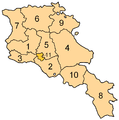
Fayl:ArmeniaNumbered.png

Size of this preview: 594 × 600 pixels. Başqa çözüm: 238 × 240 pixels | 476 × 480 pixels | 750 × 757 pixels.
Kerçek fayl (750 × 757 piksel, fayl büyükligi: 81 KB, MIME çeşiti: image/png)
Faylnıñ keçmişi
Faylnıñ kerekli anki alını körmek içün tarihqa/saatqa basıñız.
| Tarih ve saat | Kiçik resim | En × boy | Qullanıcı | İzaat | |
|---|---|---|---|---|---|
| şimdiki | 17:18, 2013 s. oktâbrniñ 13 |  | 750 × 757 (81 KB) | Fry1989 | Per AN, this type of POV is improper and unacceptable |
| 20:05, 2013 s. oktâbrniñ 11 |  | 750 × 757 (67 KB) | Ankax Hayastan | Reverted to version as of 16:47, 9 September 2010 | |
| 20:00, 2013 s. oktâbrniñ 11 |  | 750 × 757 (81 KB) | Fry1989 | Revert political POV | |
| 16:47, 2010 s. sentâbrniñ 9 |  | 750 × 757 (67 KB) | Ankax Hayastan | ((Exclaves deleted according to official map at http://www.gov.am/en/regions/)) | |
| 16:41, 2010 s. sentâbrniñ 9 |  | 750 × 757 (67 KB) | Ankax Hayastan | ((Exclaves deleted according to official map at http://www.gov.am/en/regions/)) | |
| 01:57, 2006 s. iyülniñ 30 |  | 750 × 757 (81 KB) | Aivazovsky~commonswiki | Smaller numbers work better. | |
| 20:37, 2006 s. iyülniñ 29 |  | 750 × 757 (89 KB) | Aivazovsky~commonswiki | Better version. | |
| 08:40, 2005 s. martnıñ 30 |  | 300 × 303 (29 KB) | Kocio | straight from http://en.wikipedia.org/wiki/Image:ArmeniaNumbered.png, {{GFDL}} |
Fayl qullanıluvı
Bu faylnı qullanğan saife yoq.
Umumiy fayl qullanıluvı
Bu vikilerde bu fayldı qullana:
- an.wikipedia.org qullanım
- ar.wikipedia.org qullanım
- arz.wikipedia.org qullanım
- be.wikipedia.org qullanım
- bjn.wikipedia.org qullanım
- bs.wikipedia.org qullanım
- ca.wikipedia.org qullanım
- de.wikipedia.org qullanım
- eo.wikipedia.org qullanım
- et.wikipedia.org qullanım
- eu.wikipedia.org qullanım
- fi.wikipedia.org qullanım
- gl.wikipedia.org qullanım
- hr.wikipedia.org qullanım
- id.wikipedia.org qullanım
- is.wikipedia.org qullanım
- min.wikipedia.org qullanım
- ms.wikipedia.org qullanım
- os.wikipedia.org qullanım
- pag.wikipedia.org qullanım
- pl.wikipedia.org qullanım
- sh.wikipedia.org qullanım
- sl.wikipedia.org qullanım
- su.wikipedia.org qullanım
- sv.wikipedia.org qullanım
- szl.wikipedia.org qullanım


