Fayl:2013-Aerial-Mount of Olives.jpg

Size of this preview: 800 × 443 pixels. Başqa çözüm: 320 × 177 pixels | 640 × 354 pixels | 1.024 × 567 pixels | 1.280 × 708 pixels | 2.560 × 1.417 pixels | 5.000 × 2.767 pixels.
Kerçek fayl (5.000 × 2.767 piksel, fayl büyükligi: 11,02 MB, MIME çeşiti: image/jpeg)
Faylğa ait qısqa tarif
| Tasvir |
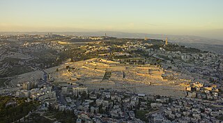
Deutsch: Der Ölberg in Jerusalem bei Sonnenuntergang in einer Luftaufnahme. Hier fand der Überlieferung nach die Himmelfahrt von Jesus Christus vierzig Tage nach seiner Auferstehung statt.
Magyar: A jeruzsálemi Olajfák hegye, ahol azt mondják, hogy Jézus a mennybe emelkedett negyven nappal a feltámadása után (Izrael)
Македонски: Маслиновата Гора во Ерусалим, каде според христијаните Исус се вознел во небесата, четириест дена по неговото воскреснување.
Português: Vista aérea do Monte das Oliveiras em Jerusalém, onde, segundo o Novo Testamento, Jesus subiu ao céu, quarenta dias depois de ressuscitar.
Українська: Оливкова гора в Єрусалимі, де згідно з Євангелієм вознісся Ісус через чотири дні після воскресіння. |
| Tarih | ~18:30 |
| Menba | Öz işi |
| Yaratıcı | Godot13 |
| İzin (Faylnı yañıdan qullanuv) |
Use outside of Wikipedia must attribute photo credit to Andrew Shiva |
| Other versions | |
| Attribution (required by the license) | Andrew Shiva / Wikipedia / |
,_2013.jpg)
,_2013.jpg)
| Object location | | View this and other nearby images on: OpenStreetMap |
|---|
Litsenziyalama
I, the copyright holder of this work, hereby publish it under the following license:
This file is licensed under the Creative Commons Attribution-Share Alike 4.0 International license.
- Azatsıñız:
- paylaşuv – qopyaluv, dağıtuv ve iletüv
- remiks etüv – uyğunlaştıruv
- Bu şartlar astında:
- attribution – You must give appropriate credit, provide a link to the license, and indicate if changes were made. You may do so in any reasonable manner, but not in any way that suggests the licensor endorses you or your use.
- aynı şekilde paylaşuv – If you remix, transform, or build upon the material, you must distribute your contributions under the same or compatible license as the original.

|
The copyright holder of this file, Andrew Shiva, allows anyone to use it for any purpose, provided that the copyright holder is properly attributed. Redistribution, derivative work, commercial use, and all other use is permitted. |
Attribution:
Use or reproduction of this image outside of Wikipedia must give the original photographer (Andrew Shiva) credit. Although not required, it would be appreciated if a message was left here indicating where this image was being used.
|
Assessment
|


|
This image has been assessed under the valued image criteria and is considered the most valued image on Commons within the scope: Mount of Olives Jewish Cemetery (Aerial view). You can see its nomination here. |
This image was selected as picture of the day on Wikimedia Commons for 25 December 2019. It was captioned as follows: English: Sunset aerial photograph of the Mount of Olives in Jerusalem, where it is said Jesus ascended into Heaven, forty days after he was resurrected. Other languages:
Deutsch: Der Ölberg in Jerusalem bei Sonnenuntergang in einer Luftaufnahme. Hier fand der Überlieferung nach die Himmelfahrt von Jesus Christus vierzig Tage nach seiner Auferstehung statt. English: Sunset aerial photograph of the Mount of Olives in Jerusalem, where it is said Jesus ascended into Heaven, forty days after he was resurrected. Español: Vista aérea del Monte de los Olivos en Jerusalén, donde, según el Nuevo Testamento, Jesús ascendió al cielo, cuarenta días después de su resurrección. Magyar: A jeruzsálemi Olajfák hegye, ahol azt mondják, hogy Jézus a mennybe emelkedett negyven nappal a feltámadása után (Izrael) Polski: Widok z lotu ptaka na Górę Oliwną w Jerozolimie, gdzie według chrześcijan miało miejsce wniebowstąpienie Jezusa 40 dni po jego zmartwychwstaniu. Português: Vista aérea do Monte das Oliveiras em Jerusalém, onde, segundo o Novo Testamento, Jesus subiu ao céu, quarenta dias depois de ressuscitar. Македонски: Маслиновата Гора во Ерусалим, каде според христијаните Исус се вознел во небесата, четириест дена по неговото воскреснување. Українська: Оливкова гора в Єрусалимі, де згідно з Євангелієм вознісся Ісус через чотири дні після воскресіння. |
| Annotations | This image is annotated: View the annotations at Commons |
Faylnıñ keçmişi
Faylnıñ kerekli anki alını körmek içün tarihqa/saatqa basıñız.
| Tarih ve saat | Kiçik resim | En × boy | Qullanıcı | İzaat | |
|---|---|---|---|---|---|
| şimdiki | 20:44, 2013 s. sentâbrniñ 26 | | 5.000 × 2.767 (11,02 MB) | Godot13 | User created page with UploadWizard |
Fayl qullanıluvı
Bu saife qullana bu fayldı:
Umumiy fayl qullanıluvı
Bu vikilerde bu fayldı qullana:
- ar.wikipedia.org qullanım
- جبل الزيتون
- بوابة:القدس/صورة مختارة
- بوابة:إسرائيل/صورة مختارة/أرشيف
- بوابة:فلسطين/صورة مختارة/أرشيف
- بوابة:الوطن العربي/صورة مختارة/أرشيف
- ويكيبيديا:صور مختارة/أماكن/مناطق حضرية
- ويكيبيديا:ترشيحات الصور المختارة/جبل الزيتون في بيت المقدس
- ويكيبيديا:صورة اليوم المختارة/مارس 2017
- قالب:صورة اليوم المختارة/2017-03-09
- بوابة:فلسطين/صورة مختارة/49
- بوابة:إسرائيل/صورة مختارة/16
- بوابة:الوطن العربي/صورة مختارة/105
- قائمة الأماكن المقدسة للمسيحيين في القدس
- بوابة:القدس/موقع مختار
- بوابة:القدس/موقع مختار/10
- بوابة:القدس/صورة مختارة/20
- ويكيبيديا:صورة اليوم المختارة/يناير 2020
- قالب:صورة اليوم المختارة/2020-01-28
- ويكيبيديا:صورة اليوم المختارة/ديسمبر 2022
- قالب:صورة اليوم المختارة/2022-12-02
- arz.wikipedia.org qullanım
- az.wikipedia.org qullanım
- bn.wikipedia.org qullanım
- ceb.wikipedia.org qullanım
- cv.wikipedia.org qullanım
- de.wikipedia.org qullanım
- de.wikivoyage.org qullanım
- el.wikipedia.org qullanım
- en.wikipedia.org qullanım
- en.wikivoyage.org qullanım
- es.wikipedia.org qullanım
- fa.wikipedia.org qullanım
- frp.wikipedia.org qullanım
- fr.wikipedia.org qullanım
- fy.wikipedia.org qullanım
- ga.wikipedia.org qullanım
- gl.wikipedia.org qullanım
- he.wikipedia.org qullanım
View more global usage of this file.